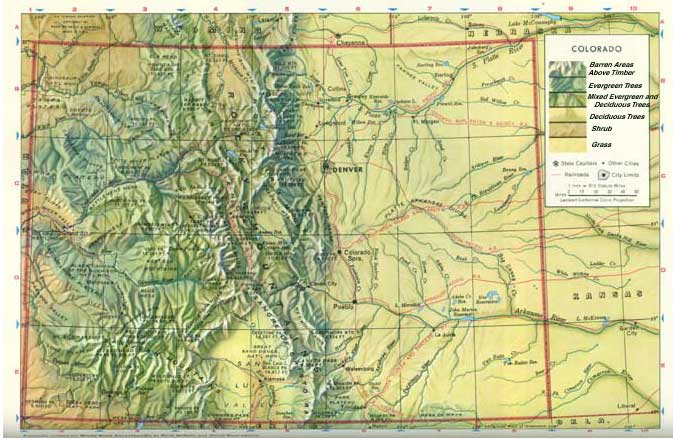
| Colorado has four main land regions: (Information and map from World Book) |
| 1. |
Colorado Plateau, along the western border, covers about a fifth of the state. It is an area of high hills, plateaus, deep vallelys, and mesas (flat-topped hills with steep sides). Farmers raise a variety of crops in the valleys. Cattle and sheep graze on the grasslands of the mesas. |
| 2. |
Intermontaine Basin, north of the plateau, is Colorado's smallest land region. It is a region of rolling hills and sagebrush plateaus wedged between mountain ranges near the northwest corner of the state. The word intermontane means between mountains. Herds of sheep graze on the plateaus, and forests cover the hills. |
| 3. |
Rocky Mountains, cover the middle two-fifths of Colorado. They also rise in the state's northwestern corner. The Colorado Rockies have been called the Roof of North America because between 50 and 60 peaks reach 14,000 feet or more above sea level. These peaks are the tallest in the entire Rocky Mountain chain, which stretches from Alaska to New Mexico.
The Continental Divide runs through the Colorado Rockies. Streams east of the divide flow into the Atlantic Ocean. Those west of it flow into the Pacific. The Colorado Rockies are one of the country's most popular areas for mountain climbing, fishing, hunting, and skiiing.
|
| 4. |
Great Plains cover roughly the eastern two-fifths of Colorado. Colorado's Great Plains region is part of the vast Interior Plain of North America that stretches from Canada to Mexico. It slopes gently upward from east to west toward the base of the Rocky Mountains. Farmers once thought the plains region wass too dry for farming. However, irrigation projects in the valleys and dry farming on the higher lands have made large-scale agreiculture possible. |
|